-
Shop our Range
▼
- Deals & Promotions ►
-
Fishing
►
Featured Fishing Categories
-
Boating
►
Featured Boating Categories
-
Camping & Hiking
►
Featured Camping & Hiking Categories
-
Marine Electronics
►
Featured Marine Electronics Categories
-
RV & Motorhomes
►
Featured RV & Motorhomes Categories
-
Apparel
►
Featured Apparel Categories
-
Watersports
►
Featured Watersports Categories
-
Diving & Snorkeling
►
Featured Diving & Snorkeling Categories
-
Hunting
►
Featured Hunting Categories
-
Shop By Brand
►
-
How Can We Help You?
Give Us A Call 0800 633 257
Or get us to call you...
Note: Our shop is open Monday to Friday 8:00am to 6:00pm, Saturday 8:00am to 5:00pm and Sunday 10:00am to 4:00pm (closed public holidays).
- Fast Shipping with CourierPost 95% orders shipped same day*
- Full Warranty We'll refund, repair or replace your item*
- No Worries Returns Submit a request, receive our return label & ship it back
- Lowest Price Guarantee Find a lower price, we'll match it or we can do better!
- Massive Range 21,000+ products in stock ready to ship!


- Details
- Specifications
- Reviews
- Questions About Product
- Details
-
Details

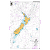
Nothing beats a proper paper chart
The ability to navigate using paper charts is absolutely critical to safe boating. If you lose visibility or your plotter fails, use this NZ Chart to navigate safely.
NZ Chart Specifications:
- Chart No: 14600
- Title: New Zealand including Norfolk and Campbell Island / Motu Ihupuku
- Int No: 600
- Scale: 1:3 500 000
- Published: April 1974
- New Edition: July 2007
- Available in NZ Mariner: Yes
- Chart No: 14600
Products You Recently Viewed
-
NZ 14600 New Zealand including Norfolk and Campbell Island / Motu Ihupuku Chart
 Why pay $26.05ONLY $23.99SAVE $2.06!
Hurry! 2 left in stock