-
Shop our Range
▼
- Deals & Promotions ►
-
Fishing
►
Featured Fishing Categories
-
Boating
►
Featured Boating Categories
-
Camping & Hiking
►
Featured Camping & Hiking Categories
-
Marine Electronics
►
Featured Marine Electronics Categories
-
RV & Motorhomes
►
Featured RV & Motorhomes Categories
-
Apparel
►
Featured Apparel Categories
-
Watersports
►
Featured Watersports Categories
-
Diving & Snorkeling
►
Featured Diving & Snorkeling Categories
-
Hunting
►
Featured Hunting Categories
-
Shop By Brand
►
-
How Can We Help You?
Give Us A Call 0800 633 257
Or get us to call you...
Note: Our shop is open Monday to Friday 8:00am to 6:00pm, Saturday 8:00am to 5:00pm and Sunday 10:00am to 4:00pm (closed public holidays).
- Fast Shipping with CourierPost 95% orders shipped same day*
- Full Warranty We'll refund, repair or replace your item*
- No Worries Returns Submit a request, receive our return label & ship it back
- Lowest Price Guarantee Find a lower price, we'll match it or we can do better!
- Massive Range 21,000+ products in stock ready to ship!


- Details
- Features
- Reviews
- Questions About Product
- Details
-
Details

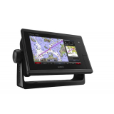
Designed for cruisers, sailors and sailing racers who demand high performance, ease of operation and feature integration, the GPSMAP 7408 chartplotter with 7-inch multi-touch widescreen display has a 10 Hz internal GPS that updates position and heading 10 times per second. It is fully network capable, including the Garmin Network and NMEA 2000, and offers the conveniences of built-in Wi-Fi connectivity.
Garmin Marine Network and NMEA 2000 SupportFull-network compatibility allows you to add more capabilities to your boat. GPSMAP 7408 supports radar, autopilot, instruments, multiple screens, FUSION-Link, sensors, remote sonar modules, digital switching, thermal cameras, GRID rotary knob, joystick and keypad control, GXM 52 Marine Weather receiver and more.
Add Array or Dome RadarYou can add your choice of Garmin marine radar, including Schumacher's powerful Xhd2 open array radars or Xhd dome radars that pairs ease of use with advanced open array features.
Network SharingGPSMAP 7408 allows you to share features with other compatible GPSMAP units, such as radar, GCV 10 DownV and SideV scanning sonar, GSD 24, GSD 25 and GSD 26 sonar modules, supplemental maps, and user data, including waypoints, routes and tracks. User data entered into 1 chartplotter can be automatically synced with other chartplotters in a network.
Heading and Position Refreshed 10 Times Per SecondFast, responsive 10 Hz GPS/GLONASS refreshes your position and heading 10 times each second to make your movement on the screen more fluid. It makes dropping up to 5,000 accurate waypoints - and finding your way back to them - quick and easy.
Special Sailing FeaturesSupported sailing features include laylines, enhanced wind rose, heading and course-over-ground lines, true wind data fields and tide/current/time slider. Gauge displays are designed to provide important need-to-know information at a glance, including true and apparent wind angle, set and drift, true or apparent wind speed, horizontal or vertical graphs, and a data bar with customizable data fields.
Compatible with gWind TransducersGarmin gWind, gWind Wireless and gWind Race transducers feature twin-fin technology with 3-bladed propeller. Connect to the NMEA 2000 and compatible Garmin chartplotters via the GND 10 black box bridge.
Black Box InterfaceThe GND 10 black box interface seamlessly integrates Nexus instruments and sensors with the Garmin family. It converts data between the Nexus network and NMEA 2000 to provide trouble-free compatibility between Nexus and Garmin products.
Upgrade with the Best Maps on the WaterTwo microSD card slots provide expandable memory for accessory map purchases, such as LakeV HD Ultra with Max Def Lakes or BlueChart g2 Vision that add Garmin patented Auto Guidance and other great features.
FUSION-Link Entertainment SystemEnjoy the ability to control all compatible FUSION-Link-enabled audio systems directly from your compatible chartplotter display.
Built-in Wi-Fi/ANT+Built-in Wi-Fi/ANT for use with Garmin Helm and BlueChart Mobile.
Garmin GPSMAP 7408 Chartplotter Worldwide Basemap Features:- 8-inch multi-touch widescreen display (1024 x 600 WSVGA)
- High-sensitivity internal 10 Hz GPS/GLONASS
- Fully network capable for Garmin Marine Network and NMEA 2000, plus NMEA 0183 support
- Supports GSD premium sonar and GCV scanning sonar modules
- Advanced sailing and sail racing features
- J1939 connection provides a dedicated CAN port for receiving engine data.
Reviews Verified by
![]()
We will send a verification email to confirm your question. All questions are subject to store approval.
The maximum number of files reached
We will send a verification email to confirm your review. All reviews are subject to approval. Personal information like emails are private and will never be shared.
-
Product Reviews (0)
Sort By:
No results found
No results found
No results found

Products You Recently Viewed
-
Garmin GPSMAP 7408 GPS Chartplotter
 ONLY $1,949.00
Out of stock