- Shop our Range ▼
-
How Can We Help You?
Give Us A Call 0800 633 257
Or get us to call you...
Note: Our shop is open Monday to Friday 8:00am to 6:00pm, Saturday 8:00am to 5:00pm and Sunday 10:00am to 4:00pm (closed public holidays).
- Fast Shipping with CourierPost 95% orders shipped same day*
- Full Warranty We'll refund, repair or replace your item*
- No Worries Returns Submit a request, receive our return label & ship it back
- Lowest Price Guarantee Find a lower price, we'll match it or we can do better!
- Massive Range 21,000+ products in stock ready to ship!
- Details
-
Details
Cover all the bases with this lean, mean, fish-finding machine
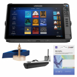
See more clearly and find more fish than ever before. The new Lowrance HDS-16 Pro Thru-Hull 1KW Chirp DEEP WATER Larger Vessel / Launch Package provides the complete package of the latest fishfinding technology. Watch fish react to your lure live with new, high-resolution ActiveTarget 2 Live Sonar, and find fish and holding structure with new, ultra high-definition Active Imaging HD. Quickly find fishing areas with the latest and most detailed charts and get full fishing system networking with expanded boat control from bow to stern. Ideal for larger vessels looking to upgrade their electronics including a high-powered through-hull transducer.
What's in the Package:- 1 x Lowrance HDS-16 PRO GPS Chartplotter/Fishfinder NZ/AU with ActiveImaging HD 3-in-1 Transducer
- 1 x Airmar XSONIC B275LH-W CHIRP Wide-Beam Thru-Hull Transducer
- 1 x C-MAP Reveal Chart - NZ/Chatham/Kermadec
Lowrance HDS-16 PRO GPS Chartplotter/Fishfinder Features:- High-definition up to 1.2MHz Active Imaging HD ready (Lowrance CHIRP/SideScan/DownScan Imaging)
- High-resolution ActiveTarget 2 Live Sonar-ready
- Supports two ActiveTarget Systems for multiple views simultaneously
- Supports new FishReveal SideScan view with a new S3100 Sonar Module (sold separately)
- Support for new ActiveTarget Scout and Ghost Trolling Motor 360 chart overlay views
- Expanded controls for the Trolling Motors, including Orbit Waypoints, Depth Routing and Anchor at a distance
- Touchscreen control of Lowrance and MotorGuide Trolling Motors, Autopilot, Lowrance Outboard Pilot and Power-Pole shallow water anchors
- NMEA 2000, Wireless and Bluetooth, connectivity – plus smartphone notifications
- Real-time mapping available with C-MAP Genesis Live
- Preloaded C-MAP DISCOVER OnBoard charts with worldwide basemap
- Wide range of optional chart upgrades including C-MAP REVEAL, Navionics and more
- Large programmable keys
Lowrance HDS-16 PRO GPS Chartplotter/Fishfinder Specifications:- Backlight colour: Pure White LED
- Display resolution: 1920 x 1080
- Screen brightness: >1200 Nits
- Viewing angles: 80° top/bottom, 80° left/right
- Display size: 16in
- Compass safe: 12" (300mm)
- Dimensions (W x H x D): 430.5 x 259.2 x 87.8 mm
- Weight: 3.60kg
- Charts supported: C-MAP Reveal, C-MAP Discover, C-MAP Reveal X, C-MAP Discover X, C-MAP (MAX N, MAX N+), C-MAP Genesis, Navionics (Gold, NAV+ Platinum+) Insight (Pro and HD), Lowrance Regional Mapping Partners
- Approvals compliance: FCC, Industry Canada, Radio Equipment Directive, ACMA, RSM
- Humidity: IEC 60945 Damp Heat 150°F (66°C) at 95% Relative Humidity (48 hrs)
- Operating temperature range: 5°F to 131°F (-15°C to 55°C)
- Shock vibration: 100,000 cycles of 20 G
- Storage temperature range: 4°F to 140°F (-20°C to 60°C)
- Waterproof rating: IPX7 with card door closed
Connectivity- Bluetooth: Integrated Bluetooth 4.0 with support for Bluetooth Classic
- Ethernet ports: 2 x 100 Mbit, 6 max MFD's on a network
- Connectivity WiFi: Internal 802.11b/g/n and Compatible with WiFi-1 Module
- NMEA 2000 connectivity: 1x Micro-C
- PC connectivity: None
- SD card storage: 2 micro SD cards up to 32GB
- Video: Output: No Input: Composite video RCA – single channel via optional adaptor
Autopilot- Manoeuvres turn patterns: Course Heading Waypoint Power Steer U-Turn C-Turn Spiral Zigzag Square Lazy-S
- Steering modes: Course Heading Waypoint Power Steer
Electrical- Power consumption max: 4.1A @ 13VDC with Full Backlight, Sonar on
- Power consumption min: 3.00A @ 13VDC with Full Backlight, Sonar on
- Power consumption typical: 3.00A @ 13VDC with Full Backlight, Sonar on
- Recommended fuse rating: 5A
- Supply voltage: 12 v DC (10.8-17VDC)
GPS- Correction: DGPS, WAAS
- GPS receiver channels: 16
- Position accuracy: 20m RMS
- Time to first fix: 30s
- Update rate: 10 Hz
MFD- AIS: AIS Chart and Radar overlay. Target vessel details
- Autopilot: Outboard Pilot NAC-1 NAC-2 Ghost Trolling Motor Motor Guide Xi5/Xi3 Trolling Motor **requires Motorguide PinPoint Gateway
- Cartography included: C-MAP Discover OnBoard (AMER models) C-MAP World Background (ROW models) Navionics basemap (AMER and ROW models)
- Digital switching: CzoneNaviop
- GPS: 10 Hz GPS/GLONASS WAAS/EGNOS/MSAS
- Internal storage: 8.0 GB Internal
- Multimedia: SonicHub SonicHub2 FusionLink products any NMEA 2000 compliant Marine Audio products
- Sonar compatibility: Integrated: CHIRP Broadband Active Imaging DownScan Active Imaging SideScan Active Imaging HD DownScan Active Imaging HD SideScan Compatible with: ActiveTarget ActiveTarget 2 S3100 SonarHub StructureScan StructureScanHD StructureScan3D LiveSight (requires PSI-1 module)
- Waypoints, Routes, Tracks: 3000 Waypoints 100 Routes 100 Trails with up to 10,000 points per trail
Lowrance Active Imaging HD 3-in-1 Transom Mount Transducer Features:- High definition (up to 1.2MHz) SideScan and DownScan Imaging deliver the clearest images of fish and structure
- Lowrance CHIRP with superb clarity and target separation
- FishReveal with new SideScan view as well DownScan
- Supports Medium and High CHIRP (83/200kHz) and 455/700/1000/1200 KHz frequencies
- Smart transducer design boosts signal clarity
- Compatible directly with Lowrance HDS PRO or with a S3100 module with HDS LIVE, HDS Carbon and Elite FS
Lowrance Active Imaging HD 3-in-1 Transom Mount Transducer Specifications:- Humidity: 60°C, 95% relative humidity (RH) for 18 hours
- Operating temperature range: 5°F to 131°F (-15°C to 55°C)
- Shock vibration: 100,000 cycles of 20 G
- Storage temperature range: -22°F to 158°F (-30°C to 70°C)
- Waterproof rating: IP67
- Mounting type: Transducer: Bracket Mount
- Weight: 1.21kg
- Interface: Direct connect to: HDS Pro S3100 Ethernet to: *HDS Live* Elite FS* Requires S3100 Module
Note: S3100 sonar module for FishReveal with new SideScan sold separately.
Airmar B275 CHIRP Wide-Beam Thru-Hull Transducer Features:- Depth and fast-response water-temperature sensor
- Low—CHIRPS from 42 kHz to 65 kHz
25° to 16° beamwidth - High—CHIRPS from 150 kHz to 250 kHz
25° constant beamwidth - 123 kHz of total bandwidth from one transducer
- Covers popular fishing frequencies of 50 and 200 kHz plus everything else in the bandwidth
- Boat Size: 8 m (25’) and above
- Hull Type: Fibreglass or wood
- Bronze transducer housing
- XSONIC connector 9-Pin
Airmar B275 CHIRP Wide-Beam Thru-Hull Transducer Specifications:- Hull Deadrise: Up to 20° with fairing
- Acoustic Window: Urethane
- Weight: 7.3 kg (16 lb)
C-MAP Reveal Chart Features:- High-definition C-MAP Reveal layer of the sea bottom on selected areas
- Reduces search time with immediate display of bottom structure, wrecks, isolated reefs and ledges
- Easy to use - turn on Shaded Relief setting on chartplotter
- Contains full C-MAP Max-N+ vector navigation data
- High resolution bathy, custom depth shading, Genesis layer and satellite imagery
- Includes detailed marina and port plans
- New Zealand, Chatham, Kermadec
- Compatible with: Lowrance Gen2 models and above, Lowrance Elite Ti2, Lowrance Elite FS, Simrad NSSevo2 and above, Simrad GO, Simrad NSO evo2 and above, B&G Vulcan, B&G Zeus2 and above, B&G Zeus2 Glass Helm and above
Products You Recently Viewed
-
Lowrance HDS-16 Pro Thru-Hull 1KW CHIRP Deep Water Larger Vessel / Launch Package
 Why pay $12,087.00ONLY $9,499.00SAVE $2,588.00!
In Stock
