-
Shop our Range
▼
-
Deals & Promotions
►
Featured Deals & Promotions
-
Fishing
►
Featured Fishing Categories
-
Boating
►
Featured Boating Categories
-
Camping & Hiking
►
Featured Camping & Hiking Categories
-
Marine Electronics
►
Featured Marine Electronics Categories
-
RV & Motorhomes
►
Featured RV & Motorhomes Categories
-
Apparel
►
Featured Apparel Categories
-
Watersports
►
Featured Watersports Categories
-
Diving & Snorkeling
►
Featured Diving & Snorkeling Categories
-
Hunting
►
Featured Hunting Categories
-
Shop By Brand
►
-
Deals & Promotions
►
-
How Can We Help You?
Give Us A Call 0800 633 257
Or get us to call you...
Note: Our shop is open Monday to Friday 8:00am to 6:00pm, Saturday 8:00am to 5:00pm and Sunday 10:00am to 4:00pm (closed public holidays).
- Fast Shipping with CourierPost 95% orders shipped same day*
- Full Warranty We'll refund, repair or replace your item*
- No Worries Returns Submit a request, receive our return label & ship it back
- Lowest Price Guarantee Find a lower price, we'll match it or we can do better!
- Massive Range 21,000+ products in stock ready to ship!


- Details
- Specifications
- Features
- Reviews
- Questions About Product
- Details
-
Details

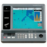
Designed for the professional
The Si-Tex Trawl Plot 12SD GPS/WAAS Chartplotter is the latest in a long line of Commercial Chart plotters that SI-TEX has produced, going back to the Fish 12. The Si-Tex Trawl Plot 12SD offers 12.1” XVGA display with 800 x 600 pixel count. The Trawl Plot also offers Easy Operation, Unlimited Storage and GPS WAAS Positioning in a daylight viewable display that can expand into an all in one GPS Chart/Fishfinder, radar when optional sensors are added. Add to all this, a newly redesigned high speed processor gives you instant screen changes and blazing fast zoom in and outs.
Si-Tex Trawl Plot 12SD GPS/WAAS Chartplotter Features:
- 12.1" XVGA Colour LCD TFT display with 800 x 600 pixels for
high-definition
- External GPS/WAAS receiver will put your boat within 3 meters
of your waypoint in most situations. Available with external
GPS/Loran receiver for True Loran Positioning as model TrawlPlot
12SDL
- Newly designed high-speed processor with INTEL XSCALE
Architecture gives you instant screen changes. Zoom level changes
appear in the blink of an eye, regardless of the amount of screen
detail
- Compatible with the new C-MAP MAX charts, technically the most
innovative C-MAP charts ever designed
- System operates as a C-MAP MAX based chart plotter with four
C-Card slots, or as a track plotter without map display.
- Guardian Programmable Anti-Grounding feature* lets you know if
your current course takes you within preset distance of charted
shoals, obstructions or other areas where the water is too shallow
for your vessel's draft.
- Expands to an all-in-one GPS Charting System/Fishfinder/Radar
with optional ES502 Fishfinder Module and optional 2kW to 4kW MDS
Radar Sensors
- Depth Graph feature accepts input from onboard sounder or
optional Active Transducer to display graphic presentation of
vessel's current depth and recent depth history
- Operates in North-Up or Track-Up modes
- Coordinates displayed in Lat/Lon, Loran TD's, or UTM
- Displays Loran TD's even when position data is supplied in
Lat/Lon coordinates
- Alphanumeric designations for easy identification of waypoints
and marks
- "One-Touch" event mark—for easy storage and retrieval of gear
marks
- Unlimited storage of track and route data on optional SD
(secure digital) memory cards
- Each disk can store up to 80,000 track plots and up to 40,000
user points of track and route data for quick recall and
display
- Tide Info feature uses local C-Card information to calculate
tide graph for local ports
- Find Function uses local C-Card to locate nearest boatyard,
bank, even the closest shower
- Joystick control of on-screen cursor to plot, scroll, pan, zoom
and place waypoints, events and marks, and to control on-screen VRM
and EBL
- GOTO and MOB functions
- Fourteen selectable languages
- Route Data Page displays waypoint position, distance and
bearing between the previous waypoint and the current one, fuel
consumption, fuel consumption between the waypoint and the first
waypoint of the route, estimated time enroute, and total
distance
- Data information window displays digital route navigation data,
and a wealth of other information
- Two NMEA-0183 dataports for interfacing data with other
on-board electronics
- Zoom into as little as 180' across screen
- Optional ES502 Fishfinder Module adds full-featured fishfinder
capabilities
Si-Tex Trawl Plot 12SD 12.1" GPS/WAAS Chartplotter Specifications:
- Power Requirement: 10 -35V DC, 15W
- Display: 12.1" (diagonal) XVGA Colour LCD TFT
- Display Resolution: 800 x 600 pixels
- Cartography: Four slots for high-definition C-MAP MAX/NT+
C-Card cartridges
- Operating Temperature: 32º to 131º
- Memory: Non-volatile with battery backup
- Technology: High-speed Intel Xscale Processor
- Cursor Control: Joystick
- Keypad: Silicon rubber, backlighted
- Storage Capacity: Unlimited with optional SD memory
card
- Waypoints/Marks: 5000
- Routes: 50 (100 wpt/route)
- Track Points: 5000
- Type of User Points: 16
- Mark Identifiers: Alphanumeric,
- Plotting Intervals: Distance - 0.01, 0.05, 0.1, 0.5, 1, 2, 5,
10 NM, Time - 1, 5, 10, 30 sec, 1 min.
- Depth Unit for Depth Line: MT, FT or FM
- Input/Output Format: NMEA-0183 Ver 2.0
- Case Dimensions/Weight: 13.5"H x 15"W x 8.9"D, 18.7
lbs.
- Receiver: L1, CA/code
- Accuracy: Better than 3m, 95% of the time
- Max. Solution Update Rate: 10/sec
- Cold Start (average): <45 sec
- Warm Start (average): <40 sec
- Hot Start (average): <8 sec
- Antenna: External
- Cable Length: 33 feet
- 12.1" XVGA Colour LCD TFT display with 800 x 600 pixels for
high-definition
Products You Recently Viewed
-
Si-Tex Trawl Pilot 12SD 12.1" Colour LCD GPS/WAAS Chartplotter
 ONLY $4,869.00
Out of stock
-
Musto Foil Impact 3/4 Neoprene Wetsuit Dark Grey/Black Size M
 Why pay $319.95ONLY $289.00SAVE $30.95!
Out of stock